Product Details
- Cover Type:
- 352 Pages
- Publisher: Crossway/Good News Publishers
- Publication Date: June 2010
- ISBN: FCURRIJODCROSSWAYESVBIBLEATLA9781433501920
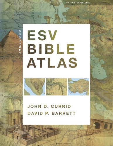
Crossway ESV Bible Atlas
Capitalizing on recent advances in satellite imaging and geographic information systems, the Crossway ESV Bible Atlas offers Bible readers a comprehensive, up-to-date resource that blends technical sophistication with readability, visual appeal, and historical and biblical accuracy.
All the key methods of presenting Bible geography and history are here, including more than 175 full-color maps, 70 photographs, 3-D re-creations of biblical objects and sites, indexes, timelines, and 65,000 words of narrative description. The atlas uniquely features regional maps detailing biblically significant areas such as Egypt, Mesopotamia, Italy, and Greece.
This carefully crafted reference tool not only sets a new standard in Bible atlases but will help ESV readers more clearly understand the world of the Bible and the meaning of Scripture.
Image Gallery
Case quantities only: USA orders will be drop-shipped directly from the publisher. Delivery will be delayed from our regular shipping schedule. Sales tax will be charged for shipments to the following states: CA, GA, KY, WA, LA, NJ, MI, RI, MA, NC, TN, IL, OH, and PA.
About the Authors
John D. Currid is the Carl McMurray Professor of Old Testament at Reformed Theological Seminary in Charlotte, North Carolina, and the author of several books and Old Testament commentaries. A PhD graduate in Syro-Palestinian archaeology (University of Chicago), he has extensive archaeological field experience from projects throughout Israel and Tunisia.
David P. Barrett, cartographer for the Crossway ESV Bible Atlas, is a Bible reference editor and the developer of Bible Mapper Software.
Endorsements (${ productEndorsements.length })
“A treasure trove...I cant endorse it highly enough. It is a must for pastors and anyone who is serious about understanding the Bible. Preachers, open this book up to the historical period of the book you are preaching from, and see if you dont learn something that helps you understand your passage for this Sunday better.”
Jamie Duguid
PhD student in Semitic and Egyptian Languages and Literatures
“I had the privilege of being involved in the production of drawings based on the latest research for the ESV Study Bible. It is a joy to see these drawings plus the original ESV Study Bible maps, woven together with numerous new maps, brilliantly evocative photographs and useful indexes to make up the new Crossway ESV Bible Atlas. This volume will become an indispensable companion for Bible students, fulfilling every expectation you might have of such a tool. Particularly innovative is the use of terrain imagery to facilitate the readers understanding of such Biblical viewpoints as that of Abraham from Hebron over the cities of the plain or Moses from Mt. Nebo.”
Leen Ritmeyer
Archaeological Consultant
“During the 44 years I served as a college professor I used many good atlases. However, I have never seen one comparable to this in the breadth of material, the depth of coverage, and the outstanding quality of its impressive and abundantly illustrated maps and photos of Bible lands.”
John McRay
Professor Emeritus of New Testament and Archaeology, Wheaton College Graduate School, Wheaton, IL
“This Atlas is a wonderfully illustrated tool to aid the layperson, student of the Scripture, or pastor who wants to dig deeper and gain new insights and appreciation of the setting, context, and message of the Bible. The text is easy to follow, pictures are brilliant, and maps are incredibly useful as the reader moves through the related narratives. I highly recommend this marvelous resource.”
James K. Hoffmeier
Professor of Old Testament & Near Eastern Archaeology, Trinity Evangelical Divinity School
“A remarkably beautiful and rich resource for historical, geographical, and archaeological background material that will deepen our understanding of each section of the Bible and increase our appreciation of the Bible's amazing historical accuracy.”
Wayne Grudem
Research Professor of Theology and Biblical Studies, Phoenix Seminary
Product Description
Capitalizing on recent advances in satellite imaging and geographic information systems, the Crossway ESV Bible Atlas offers Bible readers a comprehensive, up-to-date resource that blends technical sophistication with readability, visual appeal, and historical and biblical accuracy.
All the key methods of presenting Bible geography and history are here, including more than 175 full-color maps, 70 photographs, 3-D re-creations of biblical objects and sites, indexes, timelines, and 65,000 words of narrative description. The atlas uniquely features regional maps detailing biblically significant areas such as Egypt, Mesopotamia, Italy, and Greece.
This carefully crafted reference tool not only sets a new standard in Bible atlases but will help ESV readers more clearly understand the world of the Bible and the meaning of Scripture.
Image Gallery
Case quantities only: USA orders will be drop-shipped directly from the publisher. Delivery will be delayed from our regular shipping schedule. Sales tax will be charged for shipments to the following states: CA, GA, KY, WA, LA, NJ, MI, RI, MA, NC, TN, IL, OH, and PA.
About The Author
Product Details
- Cover Type:
- 352 Pages
- Publisher: Crossway/Good News Publishers
- Publication Date: June 2010
- ISBN: FCURRIJODCROSSWAYESVBIBLEATLA9781433501920